#northcarolina #southcarolina #weather #ncwx #scwx 🧢 MERCH: https://rstrm.io/e/YDmSpk 💸 LEAVE A TIP: https://streamelements.com/carolinawxgroup/tip 🎙️ SUBSCRIBE TO OUR PODCAST: https://anchor.fm/carolinaweather 🔔 SUPPORT US ON PATREON: https://patreon.com/carolinaweathergroup 💻 VISIT OUR WEBSITE: https://carolinaweathergroup.com The Carolina Weather Group operates a weekly talk show of the same name. Broadcasting each week from the Carolinas, the show is dedicated to covering...
Storm News:
Capturing Incredible Tornadoes LIVE: The Key to Saving Lives
The Deadly Obsession: The Real Culprit Behind Tornado Deaths
Reflecting on the Tragic Tornado Day: A Meteorologist’s Perspective
Revolutionary Weather Service Transformation: Slashes False Tornado Warnings
The Challenges of Tornadoes and Rural Support: A Personal Reflection
Unbelievable Flooding in Greensboro Revolution Mill Overwhelmed by Powerful Waters
Recapping Tuesday’s storm and forecasting Friday’s severe weather threat [Ep. 476]
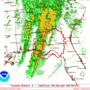
SPC Tornado Watch: Alabama, Florida, Georgia
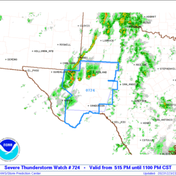
SPC Severe Thunderstorm Watch: West and Southwest Texas
Coping With Holiday Stress After a Disaster
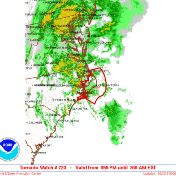
SPC Tornado Watch: North Carolina
SPC Tornado Watch: North Carolina
Be Alert to Fraud After a Disaster
How to Apply for FEMA Assistance After Severe Storms
FEMA Working Through the Holiday Season for Hurricane Idalia Survivors
Tornado warning for Halifax, Warren, Franklin counties in North Carolina
SPC Tornado Watch: North Carolina, Virginia
Tornado warning for Raleigh, North Carolina
SPC Tornado Watch: Florida
Recapping Tuesday’s storm and forecasting Friday’s severe weather threat [Ep. 476]
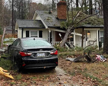
#northcarolina #southcarolina #weather #ncwx #scwx The Carolina Weather Group recaps Tuesday’s severe weather across the states, and looks ahead to another severe weather threat for Friday. On January 9, 2024, a powerful storm brought severe thunderstorms to North Carolina and South Carolina. High winds outside of thunderstorms caused tree and power line damage starting late...
SPC Tornado Watch: Alabama, Florida, Georgia
Note:
The expiration time in the watch graphic is amended if the watch is
replaced, cancelled or extended.Note: Click for Watch Status Reports.
SEL4
URGENT - IMMEDIATE BROADCAST REQUESTED
Tornado Watch Number 4
NWS Storm Prediction Center Norman OK
705 AM EST Tue Jan 9 2024
The NWS Storm Prediction Center has issued a
* Tornado Watch for portions of
Southeastern Alabama
Northern Florida and central/eastern Florida Panhandle
Southern Georgia
Coastal Waters
* Effective this Tuesday morning and afternoon from 705 AM until
200 PM EST.
* Primary threats include...
A few tornadoes likely with a couple intense tornadoes possible
Scattered damaging winds and isolated significant gusts to 75
mph possible
Isolated large hail events to 1 inch in diameter possible
SUMMARY...A severe squall line, with embedded potentially tornadic
circulations and damaging nontornadic winds, will sweep eastward
across the watch area through the remainder of the morning, into
early afternoon. A few supercells also are possible ahead of the
line with a threat for tornadoes (some strong), severe gusts and
isolated hail.
The tornado watch area is approximately along and 85 statute miles
north and south of a line from 10 miles south southwest of Crestview
FL to 55 miles east northeast of Valdosta GA. For a complete
depiction of the watch see the associated watch outline update
(WOUS64 KWNS WOU4).
PRECAUTIONARY/PREPAREDNESS ACTIONS...
REMEMBER...A Tornado Watch means conditions are favorable for
tornadoes and severe thunderstorms in and close to the watch
area. Persons in these areas should be on the lookout for
threatening weather conditions and listen for later statements
and possible warnings.
&&
OTHER WATCH INFORMATION...CONTINUE...WW 3...
AVIATION...Tornadoes and a few severe thunderstorms with hail
surface and aloft to 1 inch. Extreme turbulence and surface wind
gusts to 65 knots. A few cumulonimbi with maximum tops to 450. Mean
storm motion vector 23035.
...Edwards
SPC Severe Thunderstorm Watch: West and Southwest Texas
Note:
The expiration time in the watch graphic is amended if the watch is
replaced, cancelled or extended.Note: Click for Watch Status Reports.
SEL4
URGENT - IMMEDIATE BROADCAST REQUESTED
Severe Thunderstorm Watch Number 724
NWS Storm Prediction Center Norman OK
515 PM CST Sat Dec 23 2023
The NWS Storm Prediction Center has issued a
* Severe Thunderstorm Watch for portions of
West and Southwest Texas
* Effective this Saturday afternoon and evening from 515 PM until
1100 PM CST.
* Primary threats include...
Isolated damaging wind gusts to 65 mph possible
Isolated large hail events to 1 inch in diameter possible
SUMMARY...Strong to severe thunderstorms are expected to develop
through early evening and spread generally east-northeastward this
evening, with the strongest storms capable of hail and gusty winds.
The severe thunderstorm watch area is approximately along and 70
statute miles east and west of a line from 25 miles northwest of Big
Spring TX to 25 miles west southwest of Dryden TX. For a complete
depiction of the watch see the associated watch outline update
(WOUS64 KWNS WOU4).
PRECAUTIONARY/PREPAREDNESS ACTIONS...
REMEMBER...A Severe Thunderstorm Watch means conditions are
favorable for severe thunderstorms in and close to the watch area.
Persons in these areas should be on the lookout for threatening
weather conditions and listen for later statements and possible
warnings. Severe thunderstorms can and occasionally do produce
tornadoes.
&&
AVIATION...A few severe thunderstorms with hail surface and aloft to
1 inch. Extreme turbulence and surface wind gusts to 55 knots. A few
cumulonimbi with maximum tops to 450. Mean storm motion vector
25025.
...Guyer
Coping With Holiday Stress After a Disaster
Coping With Holiday Stress After a Disaster Holidays can bring back memories of happier times that are no longer possible after a natural disaster. If you are feeling anxious, lonely or uncertain about the future, you are not alone. You can reach out for help. The holidays may bring increased stress as traditional celebrations will...
SPC Tornado Watch: North Carolina
Note:
The expiration time in the watch graphic is amended if the watch is
replaced, cancelled or extended.Note: Click for Watch Status Reports.
SEL3
URGENT - IMMEDIATE BROADCAST REQUESTED
Tornado Watch Number 723
NWS Storm Prediction Center Norman OK
955 PM EST Sun Dec 17 2023
The NWS Storm Prediction Center has issued a
* Tornado Watch for portions of
Eastern North Carolina
Coastal Waters
* Effective this Sunday night and Monday morning from 955 PM
until 200 AM EST.
* Primary threats include...
A couple tornadoes possible
Isolated damaging wind gusts to 65 mph possible
SUMMARY...The risk for isolated severe thunderstorms will continue
to slowly shift east across eastern North Carolina tonight. A
couple of supercells may pose an isolated threat for damaging gusts
and possibly a tornado or two.
The tornado watch area is approximately along and 35 statute miles
east and west of a line from 70 miles north northeast of Cape
Hatteras NC to 70 miles southwest of Cape Hatteras NC. For a
complete depiction of the watch see the associated watch outline
update (WOUS64 KWNS WOU3).
PRECAUTIONARY/PREPAREDNESS ACTIONS...
REMEMBER...A Tornado Watch means conditions are favorable for
tornadoes and severe thunderstorms in and close to the watch
area. Persons in these areas should be on the lookout for
threatening weather conditions and listen for later statements
and possible warnings.
&&
AVIATION...Tornadoes and a few severe thunderstorms with hail
surface and aloft to 0.5 inches. Extreme turbulence and surface wind
gusts to 55 knots. A few cumulonimbi with maximum tops to 400. Mean
storm motion vector 19040.
...Smith
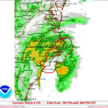
SPC Tornado Watch: North Carolina
Note:
The expiration time in the watch graphic is amended if the watch is
replaced, cancelled or extended.Note: Click for Watch Status Reports.
SEL2
URGENT - IMMEDIATE BROADCAST REQUESTED
Tornado Watch Number 722
NWS Storm Prediction Center Norman OK
150 PM EST Sun Dec 17 2023
The NWS Storm Prediction Center has issued a
* Tornado Watch for portions of
eastern North Carolina
Coastal Waters
* Effective this Sunday afternoon and evening from 150 PM until
800 PM EST.
* Primary threats include...
A few tornadoes and a couple intense tornadoes possible
Scattered damaging wind gusts to 65 mph possible
SUMMARY...Potential for locally damaging winds and a couple of
tornadoes will gradually increase this afternoon and into this
evening, as locally intense thunderstorms shift north-northeastward
across the North Carolina Coastal Plain and Outer Banks area.
The tornado watch area is approximately along and 45 statute miles
east and west of a line from 110 miles northeast of New Bern NC to
30 miles south of Wilmington NC. For a complete depiction of the
watch see the associated watch outline update (WOUS64 KWNS WOU2).
PRECAUTIONARY/PREPAREDNESS ACTIONS...
REMEMBER...A Tornado Watch means conditions are favorable for
tornadoes and severe thunderstorms in and close to the watch
area. Persons in these areas should be on the lookout for
threatening weather conditions and listen for later statements
and possible warnings.
&&
AVIATION...Tornadoes and a few severe thunderstorms with hail
surface and aloft to 0.5 inches. Extreme turbulence and surface wind
gusts to 55 knots. A few cumulonimbi with maximum tops to 400. Mean
storm motion vector 18040.
...Goss
Be Alert to Fraud After a Disaster
Be Alert to Fraud After a Disaster NASHVILLE, Tenn. – Disaster survivors should be aware that con-artists and criminals may try to obtain money or steal personal information through fraud or identity theft after a disaster. In some cases, thieves try to apply for FEMA assistance using names, addresses and Social Security numbers they have stolen...
How to Apply for FEMA Assistance After Severe Storms
How to Apply for FEMA Assistance After Severe Storms ATLANTA –Tennessee homeowners and renters in Davidson, Dickson, Montgomery and Sumner counties who had uninsured damage or losses caused by the severe storms on Dec. 9, 2023, may apply for FEMA disaster assistance. FEMA may be able to help with temporary lodging, basic home repair costs...


