Post
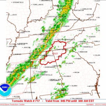
SPC Tornado Watch: Alabama, Georgia, Tennessee

SPC Tornado Watch: Alabama, Georgia, Tennessee

Note: 
The expiration time in the watch graphic is amended if the watch is
replaced, cancelled or extended.Note: Click for Watch Status Reports.
SEL7

URGENT - IMMEDIATE BROADCAST REQUESTED
Tornado Watch Number 717
NWS Storm Prediction Center Norman OK
845 PM EST Sat Dec 9 2023

The NWS Storm Prediction Center has issued a

* Tornado Watch for portions of
northern Alabama
northwestern Georgia
southeastern Tennessee

* Effective this Saturday night and Sunday morning from 845 PM
until 300 AM EST.

* Primary threats include...
A couple tornadoes possible
Scattered damaging wind gusts to 65 mph possible

SUMMARY...An advancing line of strong/locally severe thunderstorms
will continue moving eastward into/across the southern Appalachians
region this evening and into the overnight period. Locally damaging
wind gusts, and a brief tornado or two, will be the main risks with
these storms.

The tornado watch area is approximately along and 45 statute miles
east and west of a line from 60 miles northeast of Chattanooga TN to
50 miles west southwest of Rome GA. For a complete depiction of the
watch see the associated watch outline update (WOUS64 KWNS WOU7).

PRECAUTIONARY/PREPAREDNESS ACTIONS...

REMEMBER...A Tornado Watch means conditions are favorable for
tornadoes and severe thunderstorms in and close to the watch
area. Persons in these areas should be on the lookout for
threatening weather conditions and listen for later statements
and possible warnings.

&&

OTHER WATCH INFORMATION...CONTINUE...WW 715...WW 716...

AVIATION...Tornadoes and a few severe thunderstorms with hail
surface and aloft to 1 inch. Extreme turbulence and surface wind
gusts to 55 knots. A few cumulonimbi with maximum tops to 450. Mean
storm motion vector 25040.

...Goss

Post
SPC Tornado Watch Status Reports

SPC Tornado Watch Status Reports

Watch 716 Status Reports STATUS REPORT #1 ON WW 716 VALID 092245Z - 092340Z THE SEVERE WEATHER THREAT CONTINUES ACROSS THE ENTIRE WATCH AREA. ..SQUITIERI..12/09/23 ATTN...WFO...BMX...JAN...MEG... && STATUS REPORT FOR WT 716 SEVERE WEATHER THREAT CONTINUES FOR THE FOLLOWING AREAS ALC057-063-075-093-107-119-125-127-133-092340- AL . ALABAMA COUNTIES INCLUDED ARE FAYETTE GREENE LAMAR MARION PICKENS SUMTER TUSCALOOSA WALKER...

Post
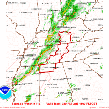
SPC Tornado Watch: Alabama, Kentucky, Tennessee

SPC Tornado Watch: Alabama, Kentucky, Tennessee

Note: 
The expiration time in the watch graphic is amended if the watch is
replaced, cancelled or extended.Note: Click for Watch Status Reports.
SEL5

URGENT - IMMEDIATE BROADCAST REQUESTED
Tornado Watch Number 715
NWS Storm Prediction Center Norman OK
320 PM CST Sat Dec 9 2023

The NWS Storm Prediction Center has issued a

* Tornado Watch for portions of
Northern Alabama
Southern Kentucky
Middle Tennessee

* Effective this Saturday afternoon and evening from 320 PM until
1100 PM CST.

* Primary threats include...
A few tornadoes possible
Scattered damaging wind gusts to 70 mph possible

SUMMARY...Severe thunderstorms including a few long-lived supercells
will move across the region late this afternoon and evening, with
the potential for all severe hazards including a few tornadoes as
well as damaging winds and some hail.

The tornado watch area is approximately along and 40 statute miles
east and west of a line from 30 miles northwest of London KY to 30
miles south southeast of Muscle Shoals AL. For a complete depiction
of the watch see the associated watch outline update (WOUS64 KWNS
WOU5).

PRECAUTIONARY/PREPAREDNESS ACTIONS...

REMEMBER...A Tornado Watch means conditions are favorable for
tornadoes and severe thunderstorms in and close to the watch
area. Persons in these areas should be on the lookout for
threatening weather conditions and listen for later statements
and possible warnings.

&&

OTHER WATCH INFORMATION...CONTINUE...WW 714...

AVIATION...Tornadoes and a few severe thunderstorms with hail
surface and aloft to 1 inch. Extreme turbulence and surface wind
gusts to 60 knots. A few cumulonimbi with maximum tops to 450. Mean
storm motion vector 24040.

...Guyer

Post
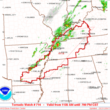
SPC Tornado Watch: Midwest

SPC Tornado Watch: Midwest

Note: 
The expiration time in the watch graphic is amended if the watch is
replaced, cancelled or extended.Note: Click for Watch Status Reports.
SEL4

URGENT - IMMEDIATE BROADCAST REQUESTED
Tornado Watch Number 714
NWS Storm Prediction Center Norman OK
1135 AM CST Sat Dec 9 2023

The NWS Storm Prediction Center has issued a

* Tornado Watch for portions of
Southeast Arkansas
Western and Central Kentucky
Northern Mississippi
Western and Middle Tennessee

* Effective this Saturday morning and evening from 1135 AM until
700 PM CST.

* Primary threats include...
A few tornadoes likely
Scattered damaging wind gusts to 70 mph possible
Isolated large hail events to 1 inch in diameter possible

SUMMARY...Strong to severe thunderstorms will continue to develop
and increase through early afternoon near an eastward-moving cold
front, with additional/more isolated development also possible ahead
of it later this afternoon. Increasingly low-level moisture and
strong shear will support the potential for severe storms including
a few tornadoes.

The tornado watch area is approximately along and 85 statute miles
east and west of a line from 30 miles north of Bowling Green KY to 5
miles east southeast of Monticello AR. For a complete depiction of
the watch see the associated watch outline update (WOUS64 KWNS
WOU4).

PRECAUTIONARY/PREPAREDNESS ACTIONS...

REMEMBER...A Tornado Watch means conditions are favorable for
tornadoes and severe thunderstorms in and close to the watch
area. Persons in these areas should be on the lookout for
threatening weather conditions and listen for later statements
and possible warnings.

&&

AVIATION...Tornadoes and a few severe thunderstorms with hail
surface and aloft to 1 inch. Extreme turbulence and surface wind
gusts to 60 knots. A few cumulonimbi with maximum tops to 450. Mean
storm motion vector 24040.

...Guyer

Post
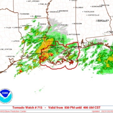
SPC Tornado Watch : Louisiana

SPC Tornado Watch : Louisiana

Note: 
The expiration time in the watch graphic is amended if the watch is
replaced, cancelled or extended.Note: Click for Watch Status Reports.
SEL3

URGENT - IMMEDIATE BROADCAST REQUESTED
Tornado Watch Number 713
NWS Storm Prediction Center Norman OK
830 PM CST Fri Dec 1 2023

The NWS Storm Prediction Center has issued a

* Tornado Watch for portions of
Southeast Louisiana
Southern Mississippi
Coastal Waters

* Effective this Friday night and Saturday morning from 830 PM
until 400 AM CST.

* Primary threats include...
A couple tornadoes possible
Isolated damaging wind gusts to 65 mph possible

SUMMARY...Thunderstorms are forecast to gradually intensify tonight
across the northern Gulf Coast. A few of the stronger storms will
potentially be capable of a supercell tornado risk. Isolated
damaging gusts are also possible with the stronger storms. The
severe threat will shift from west to east across the watch area
tonight.

The tornado watch area is approximately along and 50 statute miles
north and south of a line from 20 miles south of Intracoastal City
LA to 45 miles east southeast of Gulfport MS. For a complete
depiction of the watch see the associated watch outline update
(WOUS64 KWNS WOU3).

PRECAUTIONARY/PREPAREDNESS ACTIONS...

REMEMBER...A Tornado Watch means conditions are favorable for
tornadoes and severe thunderstorms in and close to the watch
area. Persons in these areas should be on the lookout for
threatening weather conditions and listen for later statements
and possible warnings.

&&

AVIATION...Tornadoes and a few severe thunderstorms with hail
surface and aloft to 0.5 inches. Extreme turbulence and surface wind
gusts to 55 knots. A few cumulonimbi with maximum tops to 450. Mean
storm motion vector 25035.

...Smith

Post

OUTBRK storm chasing game development update [Ep. 471]

#weather #game #videogame David Daigle-Carignan and Marc Remillard are the developers of the upcoming storm chasing video game called OUTBRK. They joined the Carolina Weather Group and the Weather Pods Disaster Relief Telethon to update the progress of their game, which will allow players to virtually chase tornadoes and storms together online. OUTBRK, which began...

Post

Storms in the Carolinas | Live local #weather radar for North Carolina & South Carolina

#northcarolina #southcarolina #weather Current, local weather conditions across both North Carolina and South Carolina featuring your local weather forecast, weather radar maps, and real-time severe weather alerts. Join us for this stream and watch live cameras in cities including Aiken, Anderson, Asheville, Boone, Charleston, Charlotte, Columbia, Fayetteville, Florence, Greensboro, Greenville, the Outer Banks and Hatteras,...

Post
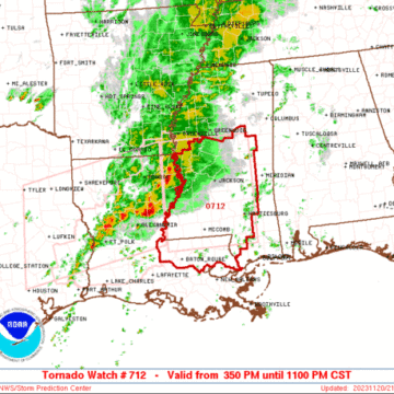
SPC Tornado Watch – Southeastern Louisiana, Southern and Central Mississippi

SPC Tornado Watch – Southeastern Louisiana, Southern and Central Mississippi

Note: 
The expiration time in the watch graphic is amended if the watch is
replaced, cancelled or extended.Note: Click for Watch Status Reports.
SEL2

URGENT - IMMEDIATE BROADCAST REQUESTED
Tornado Watch Number 712
NWS Storm Prediction Center Norman OK
350 PM CST Mon Nov 20 2023

The NWS Storm Prediction Center has issued a

* Tornado Watch for portions of
Southeastern Louisiana
Southern and Central Mississippi

* Effective this Monday afternoon and evening from 350 PM until
1100 PM CST.

* Primary threats include...
A few tornadoes likely with a couple intense tornadoes possible
Scattered damaging wind gusts to 70 mph likely
Isolated large hail events to 1.5 inches in diameter possible

SUMMARY...Thunderstorms will move eastward this afternoon and
evening while posing a threat for tornadoes, damaging winds, and
isolated hail. The threat for strong tornadoes will likely persist
with any sustained supercell.

The tornado watch area is approximately along and 90 statute miles
north and south of a line from 30 miles north northwest of Natchez
MS to 45 miles north northeast of Pine Belt MS. For a complete
depiction of the watch see the associated watch outline update
(WOUS64 KWNS WOU2).

PRECAUTIONARY/PREPAREDNESS ACTIONS...

REMEMBER...A Tornado Watch means conditions are favorable for
tornadoes and severe thunderstorms in and close to the watch
area. Persons in these areas should be on the lookout for
threatening weather conditions and listen for later statements
and possible warnings.

&&

OTHER WATCH INFORMATION...CONTINUE...WW 711...

AVIATION...Tornadoes and a few severe thunderstorms with hail
surface and aloft to 1.5 inches. Extreme turbulence and surface wind
gusts to 60 knots. A few cumulonimbi with maximum tops to 450. Mean
storm motion vector 26040.

...Gleason

Post
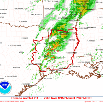
SPC Tornado Watch – Southern Arkansas, Louisiana, East Texas

SPC Tornado Watch – Southern Arkansas, Louisiana, East Texas

Note: 
The expiration time in the watch graphic is amended if the watch is
replaced, cancelled or extended.Note: Click for Watch Status Reports.
SEL1

URGENT - IMMEDIATE BROADCAST REQUESTED
Tornado Watch Number 711
NWS Storm Prediction Center Norman OK
1245 PM CST Mon Nov 20 2023

The NWS Storm Prediction Center has issued a

* Tornado Watch for portions of
Southern Arkansas
Louisiana
East Texas

* Effective this Monday afternoon and evening from 1245 PM until
700 PM CST.

* Primary threats include...
A few tornadoes likely with a couple intense tornadoes possible
Scattered large hail and isolated very large hail events to 2
inches in diameter possible
Scattered damaging wind gusts to 70 mph possible

SUMMARY...Thunderstorms will continue to intensify this afternoon
and evening, while posing a threat for large hail, damaging winds,
and tornadoes. There is also a threat for strong tornadoes through
this evening with any supercells that can be sustained.

The tornado watch area is approximately along and 85 statute miles
north and south of a line from 40 miles west of Lufkin TX to 40
miles southeast of Monroe LA. For a complete depiction of the watch
see the associated watch outline update (WOUS64 KWNS WOU1).

PRECAUTIONARY/PREPAREDNESS ACTIONS...

REMEMBER...A Tornado Watch means conditions are favorable for
tornadoes and severe thunderstorms in and close to the watch
area. Persons in these areas should be on the lookout for
threatening weather conditions and listen for later statements
and possible warnings.

&&

AVIATION...Tornadoes and a few severe thunderstorms with hail
surface and aloft to 2 inches. Extreme turbulence and surface wind
gusts to 60 knots. A few cumulonimbi with maximum tops to 350. Mean
storm motion vector 25035.

...Gleason