The Carolina Weather Group is tracking tornado-warned severe thunderstorms in the Carolinas. #northcarolina #southcarolina #weather #ncwx #scwx MERCH: https://rstrm.io/e/YDmSpk LEAVE A TIP: https://streamelements.com/carolinawxgroup/tip ️ SUBSCRIBE TO OUR PODCAST: https://anchor.fm/carolinaweather SUPPORT US ON PATREON: https://patreon.com/carolinaweathergroup VISIT OUR WEBSITE: https://carolinaweathergroup.com The Carolina Weather Group operates a weekly talk show of the same name. Broadcasting each week from...
Storm News:
Capturing Incredible Tornadoes LIVE: The Key to Saving Lives
The Deadly Obsession: The Real Culprit Behind Tornado Deaths
Reflecting on the Tragic Tornado Day: A Meteorologist’s Perspective
Revolutionary Weather Service Transformation: Slashes False Tornado Warnings
The Challenges of Tornadoes and Rural Support: A Personal Reflection
Unbelievable Flooding in Greensboro Revolution Mill Overwhelmed by Powerful Waters
Recapping Tuesday’s storm and forecasting Friday’s severe weather threat [Ep. 476]
SPC Tornado Watch: Alabama, Florida, Georgia
SPC Severe Thunderstorm Watch: West and Southwest Texas
Coping With Holiday Stress After a Disaster
SPC Tornado Watch: North Carolina
SPC Tornado Watch: North Carolina
Be Alert to Fraud After a Disaster
How to Apply for FEMA Assistance After Severe Storms
FEMA Working Through the Holiday Season for Hurricane Idalia Survivors
Tornado warning for Halifax, Warren, Franklin counties in North Carolina
SPC Tornado Watch: North Carolina, Virginia
Tornado warning for Raleigh, North Carolina
SPC Tornado Watch: Florida
Category: Local Weather
SPC Tornado Watch: North Carolina, Virginia
Note:
The expiration time in the watch graphic is amended if the watch is
replaced, cancelled or extended.Note: Click for Watch Status Reports.
SEL1
URGENT - IMMEDIATE BROADCAST REQUESTED
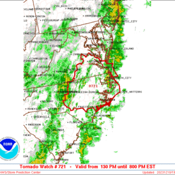
Tornado Watch Number 721
NWS Storm Prediction Center Norman OK
130 PM EST Sun Dec 10 2023
The NWS Storm Prediction Center has issued a
* Tornado Watch for portions of
Central and Eastern North Carolina
Southeast Virginia
Coastal Waters
* Effective this Sunday afternoon and evening from 130 PM until
800 PM EST.
* Primary threats include...
A couple tornadoes possible
Isolated damaging wind gusts to 65 mph possible
SUMMARY...A moist environment and stronger deep-layer/low-level
winds will support a long duration (into this evening) of at least
isolated severe storm potential, including a risk for tornadoes and
damaging winds.
The tornado watch area is approximately along and 80 statute miles
east and west of a line from 45 miles northwest of Norfolk VA to 20
miles west of Jacksonville NC. For a complete depiction of the watch
see the associated watch outline update (WOUS64 KWNS WOU1).
PRECAUTIONARY/PREPAREDNESS ACTIONS...
REMEMBER...A Tornado Watch means conditions are favorable for
tornadoes and severe thunderstorms in and close to the watch
area. Persons in these areas should be on the lookout for
threatening weather conditions and listen for later statements
and possible warnings.
&&
OTHER WATCH INFORMATION...CONTINUE...WW 720...
AVIATION...Tornadoes and a few severe thunderstorms with hail
surface and aloft to 1 inch. Extreme turbulence and surface wind
gusts to 55 knots. A few cumulonimbi with maximum tops to 500. Mean
storm motion vector 22040.
...Guyer
Tornado warning for Raleigh, North Carolina
The National Weather Service has issued a Tornado Warning for the Raleigh area of North Carolina. #northcarolina #southcarolina #weather #ncwx #scwx MERCH: https://rstrm.io/e/YDmSpk LEAVE A TIP: https://streamelements.com/carolinawxgroup/tip ️ SUBSCRIBE TO OUR PODCAST: https://anchor.fm/carolinaweather SUPPORT US ON PATREON: https://patreon.com/carolinaweathergroup VISIT OUR WEBSITE: https://carolinaweathergroup.com The Carolina Weather Group operates a weekly talk show of the same name....
Storms in the Carolinas | Live local #weather radar for North Carolina & South Carolina
#northcarolina #southcarolina #weather Current, local weather conditions across both North Carolina and South Carolina featuring your local weather forecast, weather radar maps, and real-time severe weather alerts. Join us for this stream and watch live cameras in cities including Aiken, Anderson, Asheville, Boone, Charleston, Charlotte, Columbia, Fayetteville, Florence, Greensboro, Greenville, the Outer Banks and Hatteras,...
Storms in the Carolinas | Live local #weather radar for North Carolina & South Carolina
Powered by Restream https://restream.io #northcarolina #southcarolina #weather Current, local weather conditions across both North Carolina and South Carolina featuring your local weather forecast, weather radar maps, and real-time severe weather alerts. Join us for this stream and watch live cameras in cities including Aiken, Anderson, Asheville, Boone, Charleston, Charlotte, Columbia, Fayetteville, Florence, Greensboro, Greenville, the...
Storms in the Carolinas | Live local #weather radar for North Carolina & South Carolina
#northcarolina #southcarolina #weather Current, local weather conditions across both North Carolina and South Carolina featuring your local weather forecast, weather radar maps, and real-time severe weather alerts. Join us for this stream and watch live cameras in cities including Aiken, Anderson, Asheville, Boone, Charleston, Charlotte, Columbia, Fayetteville, Florence, Greensboro, Greenville, the Outer Banks and Hatteras,...
Storms in the Carolinas | Live local #weather radar for North Carolina & South Carolina
#northcarolina #southcarolina #weather Current, local weather conditions across both North Carolina and South Carolina featuring your local weather forecast, weather radar maps, and real-time severe weather alerts. Join us for this stream and watch live cameras in cities including Aiken, Anderson, Asheville, Boone, Charleston, Charlotte, Columbia, Fayetteville, Florence, Greensboro, Greenville, the Outer Banks and Hatteras,...
Tracking Hurricane Lee | Latest forecast on the storm [Ep. 464]
The Carolina Weather Group is tracking the latest on Hurricane Lee, a strong storm in the Atlantic Ocean that has had some impressive and rapid intensification since its formation. The storm, which comes at the typical peak of the Atlantic hurricane season, has attracted much attention because of its closely-watched forecast path. Tonight, the latest...


